“The action [in Crossfire] takes place within the effective range of small arms” (p.1). Having said that there are some weapons that had very short ranges, e.g. Infantry Anti-tank weapons) so people have speculated on how to specify ranges in Crossfire. Some people have suggested introducing rulers, but this seems at odds with Crossfire’s intent, so I explored an alternative way of measuring ranges.
In my system ranges are determined by Area features (Woods, Rough, Fields, Building Sectors, etc). All you have to do is count the number of Area features from the shooter to the target. The table below gives some examples. The Average Distance given in the table assumes a Ground Scale of 1:1000. (I first thought of this when pondering how to run Crossfire in the Desert.)
Using this scheme Infantry Anti-tank weapons might be range 1/2 (or perhaps 0), HMG range 4 and other small arms range 2.
Note: I would entirely ignore Linear Features (Roads, Streams, Hedges, Walls, Wire, etc) for measuring ranges. I would only count Area Features.
| Range in Features | Description | Example on table | Average Distance |
|---|---|---|---|
| 0 | From inside one area feature a target in the same feature or From open ground to open ground with no intervening area features. |

|
60 m |
| 1/2 | From inside one area feature to open ground with no intervening area features or From open ground to an area feature with no intervening area features. |

|
120 m |
| 1 | From inside one area feature to another, adjacent area feature, with no intervening area features | 
|
240 m |
| 2 | From inside one area feature to another, adjacent area feature, with one intervening area feature | 
|
360 m |
| 3 | From inside one area feature to another, adjacent area feature, with two intervening area feature | 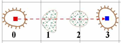
|
480 m |
| etc |
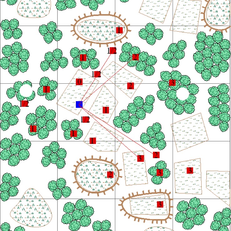
The following map shows some example ranges. All ranges are from the Blue stand. I have included some thin red lines where the LOS is a problematic (at least to me).
