I wanted to get a sense of the geography of the area in which the Rif Wars was fought.
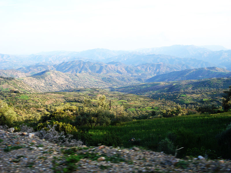
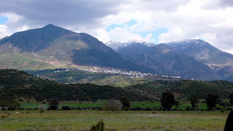
Rif Mountains
in Chefchaouen Province
Morocco
The campaigns were set in Morocco. Morocco to the English, Maroc to the French and Marruecos to the Spanish, all derived from the name of the city Marrakech. As it happens the Moroccans called their country Maghrib al Aqsa (“the Farthest West”) (Woolman, 1968).
In 1900 Morocco had three capitals: Marrakech, Fez and Meknes (Woolman, 1968). The Spanish were the only Europeans with a permanent presence in Morocco with their presidios at Melilla and Ceuta, plus Larache. Tangier was an international city.
What is the Rif?
According to Wikipedia: Rif the word Rif is الريف in Arabic and ![]() in Berber.
in Berber.
“Rif” is an Arabic word that means “an edge or an escarpment or a fertile cultivated land, the exterior of something” (Furneaux, 1967, p15). In Morocco this referred to the mountainous Mediterranean seaboard in the north.
In the 14th Century the western limit of the Rif was in the region around Ceuta and its eastern boundary was the frontier with Algeria (Furneaux, 1967). A 16th Century author defined it as the Mediterranean coast beginning near the straits of Gibraltar and extending to the Nocor river in the east, and the go south as far as the Ouarga/Wergha river.
Echoing the medieval definitions, Europeans tended to treat ” Spanish Morocco”, “the Spanish Protectorate” and “the Rif mountains” as synonyms, although this was not strictly speaking true. The area of Spanish Morocco was similar in area to the medieval definitions of the Rif, but was wider than the Rif Mountains. The Spanish controlled from the Atlantic Ocean in the west to the Muluya River close to the Algerian border (Furneaux, 1967; Woolman, 1968). The Mediterranean formed the northern border and the southern was near the Ouarga/Wergha river. About 20,000 square km in total the Protectorate extended 360 km west-east and 50 to 80 km north-south. The precise southern boundary depended on Franco-Spanish relations in a particular year.
In 1912 the Spanish set up three autonomous military commands in their zone, one in each of Ceuta, Larache, and Melilla (Fleming, 1991). In practice the Spanish seemed to have a western sector (Ceuta & Larache) and a eastern sector (Melilla) with the un-subjugated tribes in between. The western sector contained the Djebala and Gomara, mountainous areas which corresponded to distinct, non-Riffi, ethnic groups. The centre and east of Spanish Morocco made up the eastern sector, corresponding to what modern geographers call the “Rif” (Furneaux, 1967). This region contained the Rif Mountains, their hinterland, and the plain near Melilla, and was the home of the ethnic Riffi. The eastern zone was 192 km from west to east and 85 km from north to south.
The Tribes (kabyles)
“The Tunisian is a woman, the Algerian is a man,
and the Moroccan is a lion”
North African Proverb (cited in Woolman, 1968, p.30)
“No one could rule these tribes.
they are the most intractable people on earth.”
Spanish Minister at Tangier (cited in Woolman, 1968, p.22
The Spanish protectorate contained 66 tribes (Fleming, 1991; Woolman, 1968)
After the Third Rif War the Spanish divided the Protectorate into five territories (territorios) each of which contained a group of tribes (Woolman, 1968):
- Jibala (Djebala) with the Anyera, El Hauz, Wad Ras, Beni Musaur, Jebel Habib, Beni Ider, Beni Aros, Beni Lait, Beni Hassan, and Beni Hozmar tribes.
- Lukus with the Garbia, El Sahel, El Khlot, El Khlot-Tilig, Beni Gorfet, Ahl Serif, Sumata, Beni Isef, and Beni Sakkar tribes.
- Gomara with the Beni Said, Beni Ziat, Beni Zeyel, Al Ahmas, Gezawa, Beni Yahmed, Beni Kalid, Beni Erzin, Metiua, Beni Smih, Beni Gerir, Beni Buzra, Beni Selman, Beni Mansur, and Beni Zerwal tribes.
- Rif with the Mestasa, Beni Gmil, Beni Bu Frah, Targuist, Ketama, Beni Amart, Beni Urriaguel (Aith Waryaghar), Bucoya, Beni Iteft, Beni Tuzin, Geznaya and the various Senhadja tribes.
- Kert with the Temsaman, Beni Ulichek, Tafersit, Metalsa, Beni Said, Beni Bu Gafar, Beni Sicar, Mazuza, Beni Bu Hrur, Beni Sidel, Beni Bu Yahi, Ulad Stut, and Quebdana tribes.
Of these the Beni Urriaguel was the largest tribe with 35-40,000 people in the 1920s (Woolman, 1968).
Fleming (1991) divided Spanish Morocco into three areas reflecting distinct ethnic groups:
- The Djebala – presumably the Djebala and Lukus in the Woolman categorisation.
- The Gomara
- The Riff – presumably the Rif and Kert areas.
According to Wikipedia: Rif the principal Rif tribes of the region are:
- Aith Said, west of Oued Kert
- Aith Bu Yahi, along Oued Moulouya south of the Oulad Stut
- Metalsa, east of the Aith Bu Yahi
- Gzennaya, near the source of Oued Bayu, east of the Metalsa
- Aith Ouriaghel near Ajdir, around Oued Ghis (Abd el-Krim‘s tribe)
- Aith Amart, south of Aith Ouriaghel
- Targuist, southeast of Aith Ouriaghel
- Temsaman, around the town of that name, west of Al Hoceima
- Aith Ulishk, southwest of Temsaman
- Tafersit, southwest of Temsaman
- Aith Tuzin, south of Temsaman
- Bokoya, between Ajdir and Bades
- Aith Itteft, east of Bades
- Beni Guemil, west of Aith Bu Frah
- Aith Bu Frah, east of Aith Itteft
- Mestassa, east of Aith Bu Frah
- Mtiwa, between Mestassa and Oued Ouringa
- Galiya, in the region of Melilla
- Mazuza
- Aith Shisher
- Aith Sidel
- Aith Bu Ifrur
- Aith Buyafar
- Kebdana, along the coast next to Oued Moulouya near the Algerian border
- Oulad Stut, an originally Arab tribe, south of the Kebdana
Furneaux (1967) lists:
- Kebdana
- Galiya
- Beni Said
- Beni Bu yahyi
- Metalsa
- Beni Ulisik
- Tafersit
- Beni Tuzin
- Temsaman
- Qsenhaya
- Beni Urriaghel (also called Beni Wariaghel)
- Ben Amart
- Tarquist
- Bokoya
- Beni Itteft
- Beni Bir Frah
- Mestassa
- Mtiwa
Note: the Arabic Beni is equivalent to the Berber Aith, both of which mean “sons of”.
The Aith Ouriaghel were the largest group in the mid-1920 with a population of 42,000 (Fleming, 1991).
Languages
Thamazighth was the Berber language spoken by the Beni Urriaguel (Aith Waryaghar), Beni Amart, Geznaya, Bucoya, and Beni Tuzin (Woolman, 1968). These tribes are in bold in the Woolman (1968) list of tribes given above. Thamazighth is what the locals cal their language but linguistically it is called Tarifit to distinguish it from Tamazight, the family of languages, and the specific Tamazight spoken in Central Morocco (Wikipedia: Berber Languages; .
The Senhadja tribes in the Spanish and French Protectorates spoke both Arabic and a Berber language – which Woolman calls senhadji – related to Thamazighth but not entirely mutually comprehensible (Woolman, 1968).
Arabic dominated in the Djebala and Lukus although parts of the Beni Buzra and Beni Mansur in the Gomara spoke Berber dialect (Woolman, 1968). This dialect was different to both Thamazighth and senhadji.
Descriptions of the Rif
Unlike French Morocco to the south, the Spanish Protectorate featured a series of high, inaccessible mountains, interspersed by low, rolling hills (Fleming, 1991). The mountains rise abruptly from the Mediterranean and fall away more gently to the south (Woolman, 1968). The coastline had few natural harbours.
The Djebala in the western sector is a extensive area of rugged hills and narrow, lush valleys (Fleming, 1991). This area also sports the only cities in the mountains – Tetuán, Xaüen, and Wazzan (in the French Zone)
The Rif mountain chain contains rugged peaks (up to 2,100 m), wild gorges, and stony valleys (Fleming, 1991).
The western and central regions has patches of small forests, and the Gomara and Ketama has stands of Cedars (Woolman, 1968). The eastern area has less trees.
The area features cactuses, and the women of the Djebala wore leather puttees to protect themselves from their thorns (Woolman, 1968).
The area is cold and wet in winter and very hot in summer (Furneaux, 1967; Woolman, 1968). Annual rainfall varies across the region. Rainfall in the west and south is heavy but on the east it is unreliable (Balfour, 2002). Average annual rainful is 665 mm at Tetuan, 315 mm in the centre, 465 mm at Melilla. Most of the rain occurs in winter and turns the trickling streams of summer into raging torrents. Temperatures can drop below zero in all seasons except summer.
Generally infertile the area none-the-less supports a variety of trees (including fig, olive, almond, apricot), crops of vegetables, wheat, corn, rye and barley, and produced excellent honey (Furneaux, 1967; Woolman, 1968). Autumn is the planting season, winter the growing, and summer the harvest. The tribesmen also raise cows, chickens, goats and donkeys. Sheep were rare in the mountains, but more common on the plains. Only the eastern tribes living on the flat land near Melilla raised horses. [Furneax claims the Rif didn’t raise cattle, but given the system of sacrificing bulls to gain allies, there must have been a few around.]
South of Melilla the coastal Plain of Garet widens into a funnel of desert leading into the Mountains, 25 km wide and 65 km long (Woolman, 1968). This area is particularly arid.
In the early 20th Century houses were constructed around a courtyard, are either square or rectangular in shape and flat roofed, and were built from mud or stone (Furneaux, 1967; Woolman, 1968). Windows were small and became loopholes in the case of attack. Each house had a watchtower built nearby until Abd-el-Krim had these demolished in 1922. Even in a village the houses were dispersed, being perhaps 350 m apart, and surrounded by a hedge of cactus. Often a village would be strung out along mountainsides as every piece of arable land was reserved for cultivation. Near each house would be a vegetable garden, a small field of grain, and a few fruit trees.
Colours of the Rif
Early 20th Century black and white photos of the campaigns in the Rif suggest bleak stony ground. To illustrate here are a couple of photos from 1909:

Cavalry of the Orozco Division
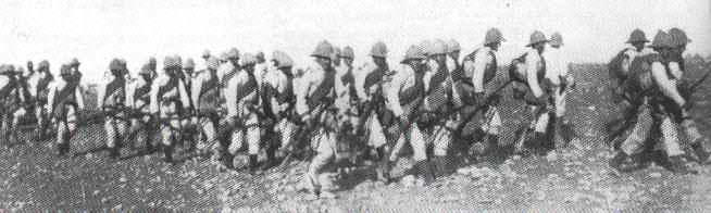
Cazadores of the Tovar Division
There is some truth to the bleak stony description but modern colour photos show a bit of green too. These are just random photos I pulled off the web. At it happens most are from around Xaüen in Djebala.
Rif Mountains Chauen
Rif Mountains in Chefchaouen Province

Rif Mountains Chefchaouen

These are the ruins of a Spanish camp in the village of Tanaqob near Xaüen
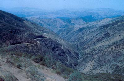
Ketama Valley in the Rif
References
Fleming, S. E. (1991). Primo de Rivera and Abd-el-Krim: The Struggle in Spanish Morocco, 1923-1927. New York: Garland.
Furneaux, R. (1967). Abdel Krim: Emir of the Rif. London: Secker & Warburg.
Woolman, D. S. (1968). Rebels in the Rif. Stanford, California: Stanford University Press.
Excellent description. Note: Targuist is actually southwest of Aith Ouriaghel.